Semantic, a big big love

August 24, 2007

As digital environments grow in sophistication and scope I sense a complementary resurgence of interest in our natural environments as well. Yet ironically features of rampant biodiversity that once survived in tandem with humanity now survive largely in spite of it; many such systems are joining an ever-longer queue to stand in topographic isolation, victims of profligate waste, consumerism or cultivated mono-agricultures. As one example: “The U.S. Department of Agriculture estimates that more than 6,000 varieties of apple trees have been lost since 1900.” To that end, I feel as though any time we can better understand even a fraction of a natural holistic system then we are closer to holding such losses at bay.

There is an unspoken positive side to over-saturation with media, a learning curve that accompanies the environment of selectivity afforded to all of us through technology. For me it comes down several key concepts: organized selectivity, interoperability, a simple design/interface, and ideally uses open-source coding/is free for users to alter. It can be as simple as the Site Search feature that Gigablast offers through its web search interface, where anyone can create a web search box for a blog or site that limits itself to a select pool of (up to) 200 web pages or files, potentially offering greater depth and authority to a guided web search. Or it can be as complex as Google Earth, where a free download allows anyone to view satellite images of any location worldwide

Organization continues to be difficult to achieve, and the reasons for this are stupefying in their complexity. Perhaps the simplest expression of these problems is the lack of a standard for archival and descriptive metadata. And that doesn’t even cover the problems associated with search terms themselves, where a search for buddha can summon results which encompass religion, Hinduism, Zen Buddhism, Osamu Tezuka, films such as Little Buddha, Buddha, or The Light of Asia, Herman Hesse, marijuana, Buddha Bar, meditation, Buddha-Heads, amulets, university and college curricula, etc etc etc.

Many of you probably already know I am referring in part to what Tim Berners-Lee called the Semantic Web. Numerous start-ups and seasoned web veterans are fast at work on developing protocols for just such a machine readable global database. In fact, this year there already are or will be several beta versions from hopeful Semantic Web wranglers; Radar Networks, TextDigger, Theseus in Germany and many many others. W3C has a dedicated Semantic Web Activity News blog that is worth subscribing to just for its window into the official side of things, with technical specs, links to rules for interoperability and notes on large-scale projects.

There is an article in the August 2007 issue of MIT’s Technology Review that inspired these thoughts, seemingly written for a budding librarian obsessed with modern systems of digital and material archiving. Second Earth by Wade Roush is essentially a current assessment of the ways in which we are realizing the Metaverse described in Neal Stephenson’s Snow Crash, or rather the Mirror Worlds hypothesized by David Gerlenter in his eponymous book of 1991. He traces the development of both Linden Lab’s Second Life as well as the wildly popular application Google Earth, and imagines the impact of viable synthesis of the two digital exo-systems.

Imagining an environment that truly simulates the Earth is far easier than realizing it. The estimated computational load alone would necessitate the dedication of, say, the surface of the moon to such a project. As Roush notes, “At one region [65,536-square-meter chunk of topographic architecture] per server, simulating just the 29.2 percent of the planet’s surface that’s dry land would require 2.5 billion servers and 150 dedicated nuclear power plants to keep them running. It’s the kind of system that doesn’t ‘scale well’.”

Regional weather tracking is one enticing reality, as is fboweb.com‘s 3-D flight tracking digital transparency for use with Google Earth. Cyber-tourism is also an intriguing possibility, helping to reduce environmental damage to fragile or endangered locations much in the way that digitization of medieval manuscripts has already done. Some cities are realizing this and Amsterdam for one has provided architectural specifications to Second Life to make visitor’s trips more realistic; Germany supplied plans and images for Berlin’s Reichstag building which now can be visited in exceptional detail by Second Lifers.

“It’s the wiring of the entire world, without the wires: tiny radio-connected sensor chips are being attached to everything worth monitoring, including bridges, ventilation systems, light fixtures, mousetraps, shipping pallets, battlefield equipment, even the human body” Even knee surgery is being improved by such sensors; three micro-sensors are inserted about the knee and GPS triangulation helps the surgeon to avoid unnecessary incisions and invasive exploration, reducing both the number of surgeries (which can be many for a knee) and an outpatient’s convalescence.

When I can ignore my skepticism and paranoia I am enchanted by the possibilities, and a small measure of my hope for humanity is restored.  As I said, I have faith in the Big Picture, and the more respect for co-dependent systems we have the closer we come to achieving a sound balance. A friend recently alerted me to Worldmapper, and their beautiful cartographic treasures seem aligned with the emerging Mirror World and with improved Semantic Web capabilities.

Through 366 world maps you are given an idiot’s guide to various global statistics, just by varying the size of geographical regions to reflect raw numbers. For example:

Want to see where people watch the most films?

worldmapper_films_watched.png

How about what regions import the most fish and fish products?

worldmapper_fish.png

Or how about regions with the most forest depletion?

worldmapper_forest_depletion.png

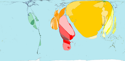
It’s unbelievable, the hypnotic range of cartograms you can find on this site, each with a detailed explanation, citations and even downloadable .pdfs for you to print out and use in any way you wish. Maps about cocoa, disease, disasters, housing, trade, food, health services, literacy, labor, maternity, migrants, sanitation…

It just blows me away each day what one can find on the web, offered free and clear to the known universe.


The Electro-Map Menagerie → Seismic Relations

July 29, 2007

Today’s Electro-Map, the final entry in our tour of cutting edge digital cartography projects, is the Seismic Monitor. This nifty little interface allows you to check out daily seismic activity around the world, both in relation to immediacy and severity. With a single click from the front page you can see the most recent earthquake news (courtesy Google), check out the last 30 days worth of earthquake activity, or even see the strangely named Special Events section wherein information about quakes with significant global impact is collected. (At first I thought, Special Events? Like earthquake parties, or events for children?)

water.gif

The data on the main map stretches back five years, with the oldest quakes depicted in purple, and the newest ones, current in the past 24 hours, shown as a throbbing, angry red animation. There are a lot more than I thought there would be, and the bit that stretches around the outer edges of Siberia down to the crown of Australia are interestingly storm-like in its pinwheel configuration. Perhaps an expert at divining earthquake patterns can educate me as to whether or not these are typical patterns, but they’re striking nonetheless.

So that’s it for the Electro-Map Menagerie, I hope you enjoyed it as much as I enjoyed finding them. If anyone has suggestions for other maps let me know; I may create a dedicated Electro-Map page at some point in the near future, as an ongoing digital cartographic archive. I didn’t even get to the Google Earth famous film locater! How many other treasures are there, glittering in the webday sun?


The Electro-Map Menagerie → Lingua America

July 28, 2007

brain-languagemap.jpg

Are you curious what languages we speak among our friends and loved one in the US of A? Well, skip on over to the Modern Language Association’s Language Map project to find out. (And yes, it is the very same MLA who publish the Style Manual) Here is the map itself, but if you’re curious about their methodology or the purpose of the map then check out their home page.

The data is culled from 2000 US census data, but it is the accessibility of the graphic itself, and the organization of the information that makes this site such a treasure. I’m sad but not surprised to discover that Hungarian is the least used language in the US, and of course Spanish is number two by a long shot. But Chinese is third? Tagalog sixth? And finally, one of my favorite features is the ability to compare language distributions using a simple side-by-side graphic display. To me, the delight of this site is just how readable dry, statistical data can be with a little imagination. I’m all the more curious now about the MLA International Bibliography on “modern languages, literatures, folklore, and linguistics.”

Tomorrow, the Electro-Map visits seismic hotspots before crossing the “t”s and dotting the “i”s on the project.


The Electro-Map Menagerie → March 20, 2003 Iraq

July 27, 2007

Today’s map is a respectful work of collective memory, in memoriam. It is the Iraq War Coalition Fatalities map.

The methodology of the map encompasses both time and space in a way other maps in the Menagerie have not done. Beginning in March, when the Iraq war officially began, and current up until February 13, 2007, the map depicts verified coalition fatalities as an animation overlaid upon a map of Iraq, showing 10 frames a second — one frame for each day. Every death is a tiny black dot, accompanied by a ticking sound which is softer or louder depending on the number of fatalities at any particular moment in time.

The criterion for verified fatalities as well as the source of the data are stated in the “about this project” section of the website. I cannot link directly to it however because the Javascript is written to encourage visitors to experience the map in a particular way. I highly recommend letting it run its course, and turning up the volume as well, even while reading the supplementary information.

I used to live in Asheville, North Carolina, and watching this map reminds me of a hotly contested billboard that was off a side street in downtown Asheville. Just after the war began, someone rented both sides of a tiny little billboard and kept a running tally (updated roughly weekly for a time) of coalition fatalities, as well as officially stated coalition force numbers and roughly estimated civilian casualties. After a time, as the war continued to grow economically and humanly burdensome, resentment about the billboard began also to grow in conservative communities, until one day a privately hired poster-board company was caught in flagrante delicto, pasting a pro-war advertisement over the already rented billboard. Once exposed, the company undid their work and claimed to not know that they were performing an illegal act, and as far as I know there was never a civil suit against them, or against the group that hired them. I eventually came to know those who posted the list of fatalities, and one of them had a son who, at the time, was serving in Iraq…

I dedicate today’s Electro-Map to that Hilliard Avenue billboard. (My only regret is that I could not find an equivalent project detailing civilian casualties, which would undoubtedly be louder and more active, but much less accurate.)

Tomorrow, an Electro-Linguistic spaghetti bowl.


The Electro-Map Menagerie → Les Cites Obscures

July 26, 2007

From Urbicande on Les Cites Obscures

Unless you can read French you may need to bring a Babel Fish along with you to enjoy today’s Electro-Map. One of the more curious corners of digital cartography is Les Cites Obscures, a free-form exploratory environment supposedly the result of “15 years of meticulous research.” It is the work of François Schuiten & Benoît Peeters who set out to create an “interactive webfiction.”

With a few judicious clicks from the cartes section of Les Cites Obscures you can travel through a tantalizing confusion of streets and geographies, while meeting sly personalities along the way. Navigating this site is reminiscent of both the first Myst game as well as my first afternoon with Nick Bantok’s Griffin and Sabine series. I only wish I knew French at all!  Either way it is a delectable cartographic treat.

Tomorrow,  the irreducible cost of war.


The Electro-Map Menagerie → Photo Graphic

July 25, 2007

You may already know about Flickr, the wonderful online photographic scrapbook that people are updating from all corners of the globe. But have you seen David Troy’s Flickrvision?

I first came across an application like this through WFMU, my vote for one of the modern Wonders of the World. During their last fund-raising marathon, enterprising DJ KenzoDB created the Marathon Map using Google Maps technology with a bit of TerraMetrics, NASA and Europa Technologies as well. This ingenious little application would track pledges from around the globe and highlight them real time, as well as make space for commentary if the generous soul wished to say something to the WFMU community at large. As I monitored their progress each day to make sure they reached the year’s fund-raising goal (which they did, yay!) I also checked in to see who was pledging and from where. Perhaps not quite a pan-continental phenomenon, they did manage to score pledges from I believe four continents. A nifty trick.

Well, Flickrvision does the idea one better. It tracks the most recently uploaded photography from around the world and pinpoints its origin for you while showing you a snapshot portrait of the fresh-from-the-oven content. I could watch it for hours….bowling in China, a Korea-Canadian baby, a dog from Seattle and…that’s weird, a note to “The Rotten Thief Who Cleaned Out Our Bank Account.” I didn’t know people photographed word documents to post on Flickr but there you go. I hope they find the culprit, that’s sad.

I don’t think I have anything to say after that.

Tomorrow, a visit to Les Cites Obscures.


The Electro-Map Menagerie → Anatomic Robotic

July 24, 2007

Mapping the human body. A Guided Tour of the Visible Human. The very fact that I can post today’s digital map is a sign of how fundamental certain changes in human society have been. Anatomical studies of the human body used to be verboten, and doctors would be reduced to grave robbery if they wished to perform autopsies. Today, things are a little different.

From the Guided Your of the Visible Human

You could start your tour of the human body with annotated images, with cross-sections such as the abdomen pictured above, or the cross-section though the thigh, but I think the following, animated bits are more what I had in mind for the Electro-Map gallery.

Transverse Plane: This section will lead you through a majestic vertical descent through a male human body. The provided gif animates 135 transverse plane cross-sections that “form a series of slices, rather like stacking a group of pancakes atop one another” in which you can clearly see a heart, liver, brain and some tiny tippie-toes. You can also choose a Coronal or a Sagittal view.

I think I could watch the transverse plane animation for hours, trying to “identify a single organ on a single pass through the body.” It’s so beautiful and entrancing, a form of meditation that I could get into.

Memory


And you wait, awaiting the one
to make your small life grow:
the mighty, the uncommon,
the awakening of stone,
the depths to be opened below.


Now duskily in the bookcase
gleam the volumes in brown and gold;
you remember lands you have wandered through,
the pictures and the garments
of women lost of old.


And you suddenly know:It was here!
you pull yourself together, and there
stands an irrevocable year
of anguish and vision and prayer.


Rainer Maria Rilke

Tomorrow, a traveling carnival of carto-photography.